Driving offroad in the wilderness or desert without a network signal is thrilling, but it comes with the risk of losing your way.
Navigating through complex urban roads can be just as challenging—hesitate for a second, and you might miss a turn and end up on the wrong street.
Or maybe you’ve found yourself wandering around a mall, trying to find a restaurant, only to walk in circles, getting more frustrated with each wrong turn.
Even going for a simple drive can become complicated when you’re constantly switching between navigation, lifestyle, search, and ticketing apps. It’s a hassle—and a safety risk.
With its latest update, Amap has addressed these headaches, along with countless other challenges that drivers might not have even thought of, by leveraging technology and innovative services.
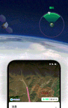
The Beidou satellite’s offline navigation and SOS features can detect areas with no network coverage ahead of time, enabling wayfinding even when the network goes dark. Amap connects to both the Beidou and Tiantong satellites, allowing users to share their location and communicate in real time. Using a spatiotemporal computing model, Amap also recommends the best lane for your route in real time, enhancing driving efficiency. Meanwhile, its 3D map feature brings cities to life, making travel planning a breeze directly on the map.
On September 3, Amap launched its 15th version, comprising an all-encompassing service map that not only offers safe, efficient, and precise driving guidance, but also taps into a rich commercial ecosystem to make your travels more enjoyable. And, thanks to improved performance, the app now consumes less battery, which is great news for those struggling with range anxiety.
The latest Amap version comes with six standout features: lane-level navigation, a 3D map, an artificial intelligence navigator, satellite SOS, offline navigation, and performance enhancements. Of these, the first three mark significant technological breakthroughs.
What does a smart map look like?
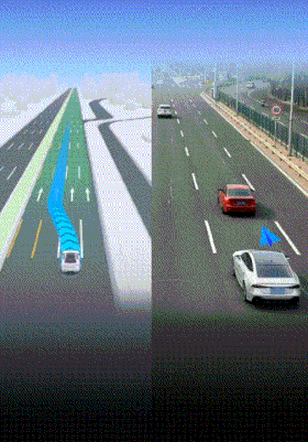
Amap’s lane-level navigation shows that a smart map doesn’t just give directions—it warns you about upcoming changes and uses spatiotemporal computing to recommend the best lane in real time. This is a first for the industry.
According to Amap’s team, the system relies on advanced spatiotemporal perception models that provide precise lane prompts and driving recommendations up to 30 seconds ahead.
The precision of Amap’s lane-level navigation is built on three pillars:
- Nationwide lane and network coverage, supported by Beidou’s high-precision signals, bringing location accuracy down to within one meter.
- Enhanced spatiotemporal computing capabilities that enable smarter lane guidance, combining high-quality positioning data from Beidou with real-time traffic analysis.
- Sophisticated modeling techniques developed by Amap, enabling it to map and predict complex traffic flows.
One example of Amap’s innovation is its collaboration with Hangzhou’s traffic police, where the system identified the city’s 50 most congested intersections. By analyzing congestion indices, queue lengths, and stop counts, Amap offered comprehensive solutions to optimize traffic light timing, adjust variable lanes, and help direct police efforts. As a result, intersections once rated as severely congested have seen significant upgrades in ratings.
The new version uses even more advanced computing power. For instance, the lane-level navigation feature now integrates multiple data streams, calculating faster routes in real time. The system incorporates dynamic visual guidance, intelligent voice prompts, and gamified feedback to boost interactivity and efficiency, especially on highways.
Amap’s lane-level navigation has evolved in three phases: from offering lane-level navigation (enhanced driving guidance) to lane-level safety alerts (anticipating and warning users about upcoming road conditions), and now to lane-level navigation (recommending lane changes based on real-time conditions). All of this is powered by Amap’s self-developed spatiotemporal perception models.
What’s notable is that Amap makes this technology accessible to everyone. There’s no need for smart vehicles or high-performance chips—any regular car with an Android phone can access lane-level navigation through the Amap app.
More than mere maps
Along with lane-level navigation, Amap’s advancements in 3D maps and the AI navigator point to a future where maps are dynamic, interactive, and three-dimensional.
According to the head of Amap’s 3D map division, the intention was to create maps that feel vivid and immersive, offering a better visual experience and smoother spatial navigation.
Amap’s 3D models are generated using its proprietary rendering technology, enabling the exploration of 3D cityscapes from all angles. The models are optimized for smooth performance on all types of devices.
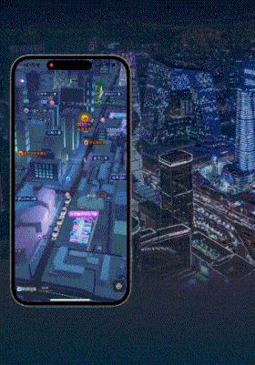
This 3D map feature is designed to meet evolving consumer needs—it looks cooler and is easier to use. But beyond the visual appeal, these maps are also functional.
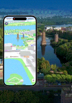
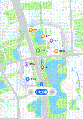
Different destinations create different consumer needs, and Amap’s vast consumer data fuels the new “reachable zone” feature, which helps users quickly locate points of interest within their area.
This feature acts like a mini-radar, showing nearby restaurants, entertainment options, and amenities. Users can filter locations by walking distance, whether 5, 10, or 15 minutes away.
For instance, zooming in on Amap’s 3D map, nearby commercial areas appear as heatmaps. Users can then explore the details of these areas, including the floor plans and store locations of high-rise buildings.
Another standout feature is the AI navigator, designed to act as both a companion and assistant as users navigate or access location-based services.
Along with satellite SOS, offline navigation, and performance improvements, Amap’s latest version delivers full coverage while addressing concerns about battery life.
Data shows that the new version boosts app startup speed by 89%, improves overall performance by 90%, reduces storage usage by 50%, and conserves over 30% more battery than before.
Converting tech assets into time-saving tools
With the rise of AI and precision mapping powered by large models, the digital mapping industry is transforming. Amap is now becoming not only a critical geographic tool but also a potential solution for big data visualization systems.
With the introduction of large models, Amap’s ability to perceive spatiotemporal data is said to have improved significantly. For instance, roadside data captured by vehicle cameras, which wasn’t previously considered part of spatiotemporal data, can now be understood in that context thanks to multimodal technologies.
As an example, marathon event data—once just text and images—can now be converted into spatiotemporal data that highlights real-time road closures.
Amap has already shown its ability to calculate traffic light patterns based on vast amounts of user-generated data. Essentially, Amap’s system calculates the status of red and green lights by analyzing whether users are driving or waiting at intersections.
While large models are now used for these computations, spatial judgment still has room to improve.
Amap’s lane-level navigation sees beyond the horizon, detecting road conditions that are out of sight or camera range. It also gathers data from surrounding users, bypassing obstacles like large trucks or buses.
In summary, Amap’s dedication to AI and innovation is transforming technological assets into time-saving tools, forming a moat. Its streamlined tech review processes have become valuable assets, setting barriers that competitors will likely struggle to overcome.
KrASIA Connection features translated and adapted content that was originally published by 36Kr. This article was written by Xiao Xi for 36Kr.